

UPDATE 4/17/16 (or should this be labeled a -DOWNDATE?) SEE THE CURRENT KIHEI-MAKENA COMMUNITY PLAN
Sometime back, probably in the ’80’s, the South Maui Community examined the condition of the poor or lack of planning of our area, and began striving to improve what existed & insure that all new growth and the built environment was completed in a more progressive and positive way. A part of that desire was creation of what was designated a “walkable-bikeable” community, with interconnected greenways, contiguous sidewalks and bike paths.
When is was time to update the Kihei Makana Community Plan a decade later, these concepts were included in numerous sections of this document legalized by the County Council in 1998. (See some excerpts from the KMCP below)
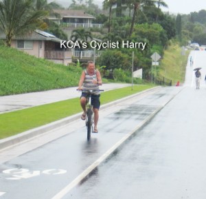
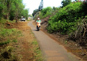
So decades later what has occurred instituting this desired and legalized community request? ( BICYCLING) In this century, we have a superb greenway mauka Liloa from Waipulani southbound to Lipoa and now under construction one block further south. The State DOT built a segregated bike path along the length of the rebuilt Mokulele Highway. What else? Well there are no other bike paths at all. We do have some marked bike lanes (meaning a white line is painted between the main roadway and the shoulder) with accompanying signs advising this is a bike lane, which offers 0 protection for cyclists. We have some roadways (e.g. segments of Kenolio Rd) designated as shared roadways, meaning bicyclist and motor vehicles can travel the same roadway. Is this safe?
What is in the future. Well the KCA proposed simple paved (asphalt strip) across the makai edge of the Community park to allow residents in the Waimahaihai neighborhood to safely bicycle to both schools as well as connect to the soon to be completed bike path has been placed on hold. The Waipulani Bike Path across that park, which had been announced to begin construction in 2014 (SEE)
https://gokihei.org/environment/the-next-bike-path-for-kihei-waipuilani
is now potentially pushed back even further to 2019 in the STIP. . So much for bikeable.
How about (WALKABLE) pedestrians? How many streets do you observe which have a continuous sidewalk? If you find them do they run through between the Highway and SKR? They sure are few and far between. Of course our only contiguous N-S road across all of Kihei, South Kihei Road (SKR) is sorely lacking sidewalks in countless areas.
County DPW is currently working with KCA on a list of prioritized areas in need of contiguous sidewalks. And just accomplished the most glaring needs of SKR in No, Kihei is the 1st manini step. But there is no commitment to accept our requests soon. Maybe next time?
We skimmed through the KMCP for some mention about the walkable-bikeable concepts & needs: WHEW!
“ There is a need to lessen the dependence on automobiles through efficient land use distributions. Bicycle and pedestrian paths separate from automobile traffic would provide an effective alternative to the automobile “
“Upon adoption of this plan, it shall be required that adequate facilities and infrastructure will be built concurrent with future development.”
“ A trail/greenway/bikeway system is also being proposed to provide alternate means of transportation. “
“ Upon adoption of this plan, allow no further development unless infrastructure, public facilities, and services needed to service new development are available prior to or concurrent with the impacts of new development. “
“ Establish a system of parks, utility easements, shoreline areas, drainageways and wetlands as an open space framework for the urban areas of the region, i.e. where structures exist or are planned to exist, and provide an integrated system of pedestrian and bicycle paths. “
“ minimize dependence on automobiles. “
“Prepare an Open Space Master Plan for the region to provide a unified system of non-motorized access to community resources, and to provide a planned program of resource stewardship. Establish standards for the use of drainageways, gulches, wetlands, and easements for public access.”
“ Require the integration of wetlands and drainageways into an open space, pedestrian pathway, and bikeway system within and around the Lipoa business district.”
“Partner with the Na Ala Hele, South Maui Heritage Corridor, Kihei 2000, and Bikeways Maui organizations to establish a continuous trail/greenway/bikeway system from Kealia Pond to Kilohana Road, to provide pedestrian lateral accesses to the Kihei-Makena shoreline, and to protect and maintain traditional shoreline access. “
“ Include a pedestrian and bikepath to allow school children to access the beach and greenway. “
“Developments shall provide space for landscaped pedestrian ways and bikeways.”
“New residential communities should provide convenient pedestrian and bicycle access between residences and neighborhood commercial areas, parks and public facilities.”
“Support ridesharing, bicycle and pedestrian use, alternative work schedules, traffic signal synchronization, and/or other transportation demand management strategies “
“Plan, design, and construct a pedestrian and bikeway network throughout the Kihei-Makena region which considers the utilization of existing stream beds, drainageways, wetlands and public rights-of-way along coastal and inland areas.”
“ …implement an adjacent but separate trail/greenway/bikepath to provide non-motorized public access along the full length of the road reserve. In sections where no roadway is built, the trail/greenway/bikepath may be broadened to form a neighborhood park, public access, or open space area. “
“a pedestrian and bicycle recreation way along the existing utility rights-of-way.
“pedestrian/bicycle paths, “
“park linked to the neighborhoods with a pedestrian/bicycle path. “
So what happened to the plan that the Council approved? Do what we have sound like what the Plan called for 18 years ago?
The Planning Department hires a professional to develop or update a current plan, which is offered to the citizen volunteer group (CPAC). These volunteers dedicate months of their time formulating this into what the community expresses they want, and passes onto the next volunteer group, the Maui Planning Commission, who refine and modify it. In turn they send on to the Administration’s professional Planning Department, and finally the elected Council makes it their plan, & it becomes law.
So who enforces this? How can we have a plan established by our elected county legislators, so concentrated with countless items for a walkable/bikeable community, and then we get nothing close to this? Almost two decades after the elected Representatives say this is the plan, where is the implantation? Why should all the volunteers,as well as County employees and our elected officials spend all this time and money (How much does all of this cost??) if is in really ineffective? Who is responsible?
Probably in a few years the process for the updated KMCP may begin anew (maybe ten years overdue.). Before all the time effort and money is expended again, is there a practical reason for it, if the plan comes across as merely lip service? Walking, not talking gets it done.
See our current KMCP at http://maui-communities.weebly.com/kihei–makena-south-maui.html
Segments of NSCR corridor across Kihei in various states shown below:


Discover more from Kihei Community Association | Maui, Hawaii
Subscribe to get the latest posts sent to your email.
